—Terrence Dorner, B1Daily
In military operations, intelligence is not simply an advantage. It is the foundation upon which successful operations are planned, coordinated, and executed. An adversary who can observe your movements, identify your infrastructure, and monitor your preparations possesses a potentially decisive advantage before the first shot is fired.
Beijing understands this principle exceptionally well.
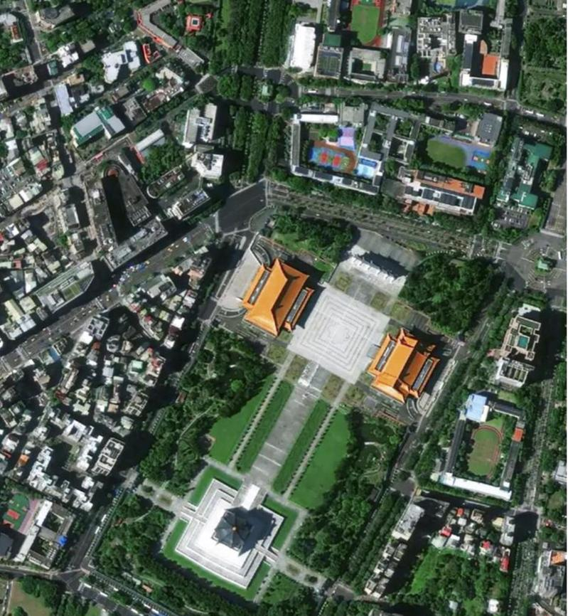
China recently demonstrated its expanding space-based intelligence capabilities by releasing remarkably detailed satellite imagery of Taiwan, showcasing the growing sophistication of its orbital surveillance infrastructure.
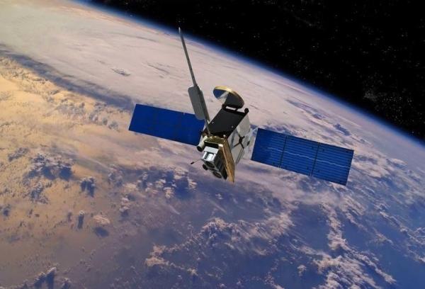
The footage, released by Chinese state broadcaster CCTV, originated from the country’s commercial Jilin-1 remote-sensing satellite constellation. The 42-second presentation displayed recognizable Taiwanese landmarks, infrastructure, and geographic features with impressive clarity.
Taiwanese defense officials immediately recognized the implications.
Defense Minister Wellington Koo Li-hsiung pledged continued vigilance against Chinese intelligence collection and emphasized the importance of concealment, mobility, and dispersal to protect Taiwan’s armed forces.
From a military intelligence perspective, Beijing’s message was unmistakable: China wants Taiwan to understand that its territory is being watched from above.
Jilin-1: Commercial Satellites With Strategic Military Implications
The Jilin-1 constellation represents an important development in China’s intelligence, surveillance, and reconnaissance capabilities, commonly designated ISR within military circles.
Unlike traditional military reconnaissance programs, Jilin-1 operates commercially. Nevertheless, high-resolution commercial imagery can provide valuable intelligence to military planners.
This distinction matters because modern warfare increasingly depends on information collected through both civilian and military systems.
Satellite imagery can support terrain analysis, infrastructure mapping, operational planning, and assessments of activity over time. When combined with other intelligence sources, it can help military analysts develop a more comprehensive understanding of an adversary’s capabilities.
The footage released by Beijing included the Port of Taipei, Taipei Dome, National Palace Museum, and Chiang Kai-shek Memorial Hall, alongside prominent natural features.
These are publicly recognizable locations rather than proof that China has penetrated Taiwan’s most sensitive military facilities.
However, the demonstration illustrates the potential value of a satellite constellation capable of collecting detailed imagery across geographically dispersed locations.
The important question is not whether China can photograph a building. It is how effectively Beijing can convert imagery into timely, actionable military intelligence.
That distinction separates an impressive surveillance demonstration from a genuinely formidable reconnaissance capability.
Beijing Is Building More Than a Collection of Satellites
China’s investment in space-based reconnaissance reflects a broader military modernization strategy.
The People’s Liberation Army has spent years developing capabilities intended to improve battlefield awareness, communications, navigation, and precision-strike operations.
For military commanders, the objective is to shorten the time between detecting a potential target and making an operational decision.
This process is commonly associated with the military kill chain: finding, fixing, tracking, targeting, engaging, and assessing.
Space-based ISR can contribute to several stages of that process, particularly when integrated with aircraft, unmanned systems, radar networks, and other sensors.
But satellite imagery alone does not complete the kill chain.
Military planners still require accurate identification, dependable communications, current intelligence, and reliable command-and-control systems.
A satellite image may identify a facility’s location. It does not necessarily establish what is happening inside, whether a particular military asset is present, or whether that information remains current.
Even so, China’s expanding ability to collect imagery represents a serious intelligence consideration for Taiwan and the United States.
Taiwan’s Military Understands the Threat
Taiwan’s defense establishment is not treating Beijing’s satellite demonstration as harmless publicity.
Defense Minister Wellington Koo has emphasized the necessity of early warning, concealment, mobility, and force dispersal.
These are fundamental military countermeasures against persistent enemy surveillance.
The logic is straightforward: a military force that remains stationary and predictable becomes easier to monitor. A force that protects its operational information and maintains flexibility is more difficult to assess.
For Taiwan, this is particularly important because of the island’s geographic limitations and the People’s Liberation Army’s substantial conventional military capabilities.
China does not necessarily need to invade Taiwan to exploit superior intelligence collection.
Persistent surveillance can support military pressure, inform coercive operations, and complicate an adversary’s defense planning.
From an operational standpoint, the ability to maintain situational awareness during a crisis could prove just as important as the number of aircraft or warships available.
Washington Should Be Paying Attention
The implications extend well beyond Taiwan.
American military planners must consider China’s growing ability to observe activity throughout the Western Pacific.
U.S. naval installations, regional airfields, logistics facilities, and maritime traffic are all potential subjects of Chinese intelligence collection.
Commercial satellite imagery is not inherently classified or exclusively military. However, when imagery is integrated with other sources, it can contribute to a sophisticated intelligence picture.
That creates challenges for American forces operating across the Indo-Pacific.
The United States has long enjoyed major advantages in space-based reconnaissance, but China is investing heavily in narrowing those advantages.
Washington cannot assume that American military movements will remain difficult to observe simply because operations take place thousands of miles from mainland China.
The modern battlefield extends far beyond the immediate combat zone.
Beijing Is Also Conducting Psychological Operations
There is another dimension to this satellite demonstration that deserves attention: psychological warfare.
Beijing did not release these images in a political vacuum.
The footage accompanied Chinese messaging commemorating the end of Japanese rule over Taiwan. CCTV presented the island as Chinese territory and concluded with language emphasizing eventual unification.
That makes the imagery more than a technological demonstration.
It was also a strategic communication exercise designed to reinforce Beijing’s territorial claims and showcase its ability to observe Taiwan.
In military terminology, this falls within the broader realm of information operations.
China is demonstrating capability while attempting to influence how Taiwanese officials, military personnel, and civilians perceive Beijing’s power.
However, the publicly released footage does not establish that Chinese satellites can continuously track every Taiwanese military asset or provide uninterrupted targeting information.
Those capabilities would require additional evidence.
The message is psychological, but the underlying surveillance technology is real.
The Next War Could Be Decided Before the First Missile Launches
Military history repeatedly demonstrates the value of superior reconnaissance.
Modern warfare has only increased that importance.
The integration of satellite imagery, electronic intelligence, unmanned surveillance platforms, and advanced data processing is changing how armed forces understand the battlespace.
For China, the objective is increasingly clear: develop the ability to observe, assess, and respond to military activity throughout its strategic operating environment.
For Taiwan, the challenge is maintaining operational security against a technologically sophisticated and geographically close adversary.
For the United States, the challenge is preserving its military advantages against a competitor investing enormous resources in space-based intelligence.
Beijing’s latest imagery release should not be mistaken for proof of total surveillance dominance. But dismissing it as propaganda would be equally foolish.
China is building an increasingly capable intelligence apparatus, and the People’s Liberation Army understands that information superiority can translate directly into military advantage.
The lesson for American and Taiwanese defense planners is simple.
Never underestimate an adversary’s reconnaissance capabilities. Never assume your movements are invisible. And never confuse an absence of gunfire with an absence of military operations.
Because in modern warfare, the intelligence battle begins long before the shooting starts.
And Beijing intends to be watching.
—Terrence Dorner, B1Daily





Leave a Reply